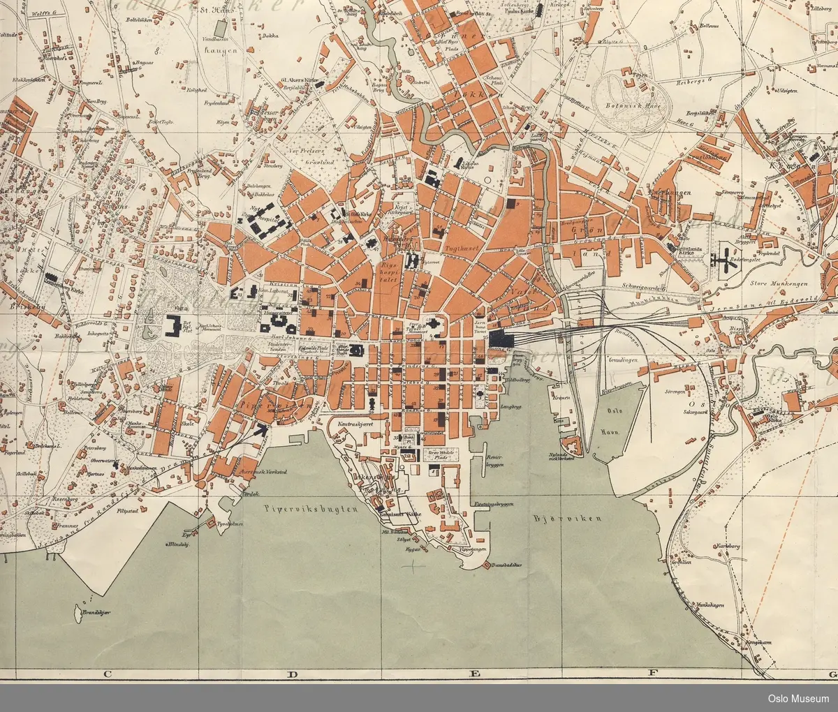
Photo: Oslo Museum Accept license and download photo Kart over Christiania udgivet ifølge Kommunebestyrelsens Foranstaltning, med Rettelser til 1ste januar 1868 [kobberstikk] Skillebekk - Grønnlia - Galgeberg - Tøyen - Sandaker - Adamstuen. Bebyggelsen gråskravert. Biklart over Hegdehaugen og Briskeby. icon--add Add to folder icon--add Add to folder Remove from folder Order image 0 Comment/inquiry social--facebook social--more Share About the object TitleKart over Christiania udgivet ifølge Kommunebestyrelsens Foranstaltning, med Rettelser til 1ste januar 1868 IdentifierOB.05071 DimensionsMålestokk 1 : 5 000 Type Fineart Indexing termtopografi bydeler bygninger kartverk kart SubjectSkillebekk - Grønnlia - Galgeberg - Tøyen - Sandaker - Adamstuen. Bebyggelsen gråskravert. Biklart over Hegdehaugen og Briskeby. TitleKart over Christiania udgivet ifølge Kommunebestyrelsens Foranstaltning, med Rettelser til 1ste januar 1868original Designationkart Precise designation kobberstikkgrafikk Catalog levelEnkeltverk Dimensions value Bredde96.6 cmHøyde79.8 cm TechniquesKobberstikk Håndkolorering Created with Sketch. Add a comment or suggest edits Produsent (K) History Produksjon: 1868 Produsent (K)Næser, Johan Wilhelm GeorgStøper, trykker eller annen produsent ved mangfoldiggjøring av katalogisert verk B/KI)H. N. Bergh (kobberstikking) Created with Sketch. Add a comment or suggest edits License information License Attribution (CC BY) Metadata IdentifierOB.05071 Part of collectionByhistorisk samling Owner of collectionOslo Museum InstitutionOslo Museum Date publishedMarch 14, 2017 Date updatedJanuary 12, 2024 DIMU-CODE021046922929 UUID797325cb-2b0b-4ba4-b88e-cdae0c1aea8e Tags For adding tags, log in. There are 42 results for «topografi» in Oslo Museum: Qaradaki, Shwan Dler The Golden Ghetto [akryl] Laan, Theophilius Prospect over Christiania [gra... Bloch, Andreas Holmenkollen med sportsrestaur... Kart over Christiania. Maalestok 1 : 7000 af den sande størrelse.... Kart over Hammersborg [kart] View more Add a comment or suggest edits To publish a public comment on the object, select «Leave a comment». To send an inquiry directly to the museum, select «Send an inquiry». Leave a comment or send an inquiry You are not logged in – Log in You are not logged in – Log in Your name Your email Add comment or cancel Send an inquiry Your message will be sent to Oslo Museum. Recipient Message You are not logged in – Log in Your name Your email Send email or cancel New comment or inquiry

")

![The Golden Ghetto [akryl]](https://dms-cf-01.dimu.org/image/0138Wuk4F2Fc?dimension=250x250)
![Prospect over Christiania [grafikk]](https://dms-cf-09.dimu.org/image/012uMXPwTEy2?dimension=250x250)
![Holmenkollen med sportsrestauranten [lavering]](https://dms-cf-05.dimu.org/image/0231vy8MsbBv?dimension=250x250)

![Kart over Hammersborg [kart]](https://dms-cf-03.dimu.org/image/032yjVV6Xbbw?dimension=250x250)
Add a comment or suggest edits
To publish a public comment on the object, select «Leave a comment». To send an inquiry directly to the museum, select «Send an inquiry».